Home Multi-Country Search About Admin Login
Cenozoic
Cretaceous
Jurassic
Triassic
Permian
Carboniferous
Devonian
Early Paleozoic

Search by
Select Region(s) to search
Hold Ctrl (Windows/Linux) or Command (Mac) to select multiple
Trang Formation
Click to display on map of the Ancient World at:
Trang Fm base reconstruction

Trang Fm


Period: 
Neogene

Age Interval: 
Middle Miocene (1,2)


Province: 
Andaman Sea: Mergui Basin

Type Locality and Naming

At the Trang well between interval 2,670-5,110 feet. The Trang formation was first named by Nakanart and Mantajit (1983). Information below is combined with Polachan (1988). Parent unit: Mergui Gr.

Synonym: หมวดหินตรัง

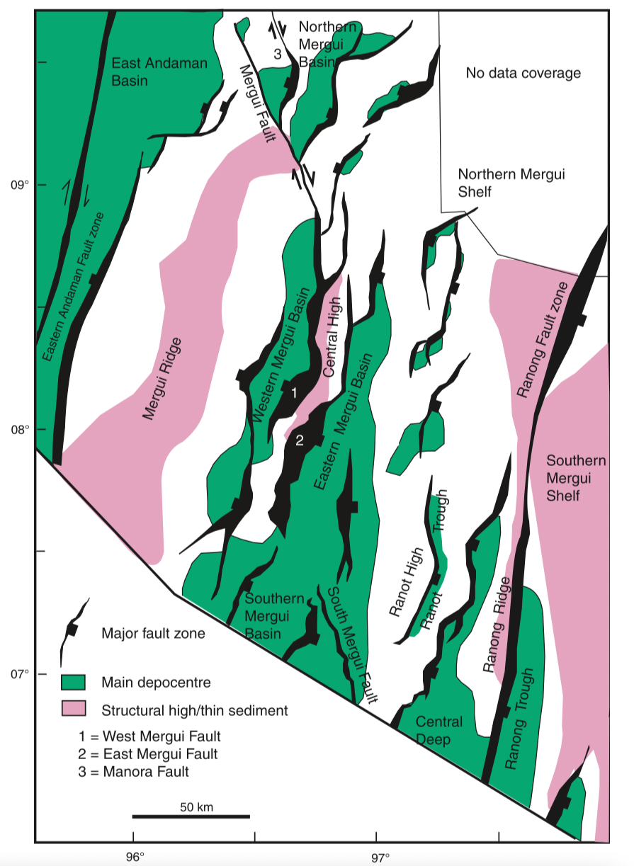
[Figure 1: Map of the Mergui Basin showing the main structural features including basin depocentres, based on an extensive grid of 2D seismic reflection data. (From C K Morley & A Racey, 2011)]


Lithology and Thickness

Mainly grey glauconitic shales in the lower part, and turbidites in the upper part. Thickness: 732 m at the type section, 231 m at the E-1 well.

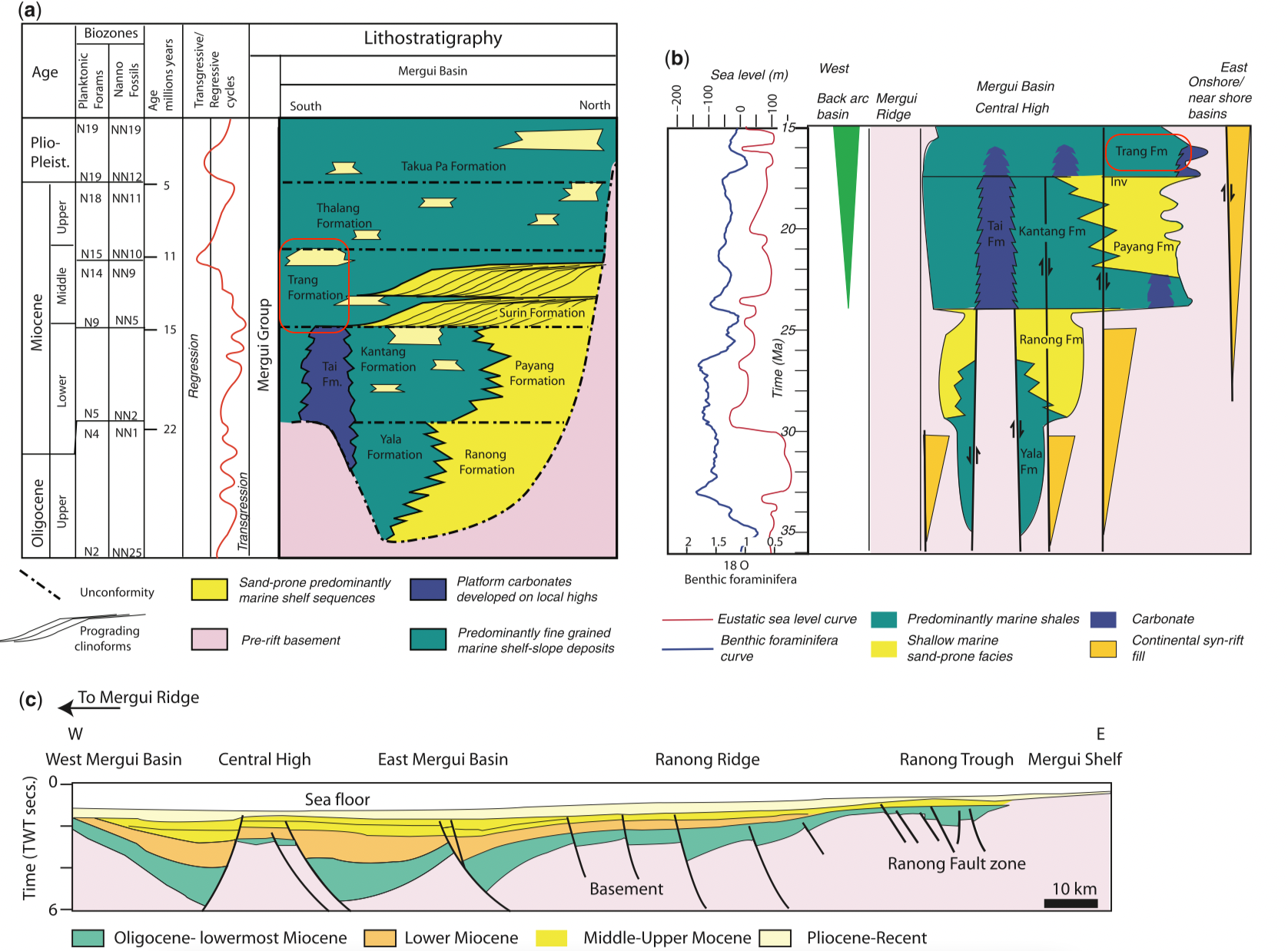
[Figure 2: Stratigraphy and cross-section through the Mergui Basin, Andaman Sea, based on data in Polachan & Racey (1994) and Andreason et al. (1997). (a) Oligocene–Recent stratigraphy of the Mergui Basin; (b) stratigraphy of the syn-rift section (Oligocene–early Miocene) schematically illustrating the east–west variation in stratigraphy across the basin and the effect of rift-basin highs (e.g. Central High horst block) on large-scale distribution of sedimentary facies, modified from Andreason et al. (1997); (c) east–west cross-section through the Mergui Basin illustrating the typical half-graben geometries of the basin (modified from Polachan & Racey 1994). (From C K Morley & A Racey, 2011)]


Lithology Pattern: 
Sandy claystone


Relationships and Distribution

Lower contact

Kantang Fm or Tai Fm in South Mergui Basin, or Surin Fm in North Mergui Basin (conformable)

Upper contact

Thalang Fm (unconformable)

Regional extent

Andaman Sea: Mergui Basin. Correlation: Baong Fm of North Sumatra Basin


GeoJSON

{"type":"Feature","geometry":{"type":"MultiPolygon","coordinates":[[[[96.48,9.7],[96.78,9.77],[97.12,9.72],[97.23,9.62],[97.27,9.49],[97.28,9.32],[97.31,9.16],[97.38,9.03],[97.43,8.93],[97.49,8.76],[97.47,8.67],[97.46,8.54],[97.47,8.44],[97.53,8.3],[97.55,8.13],[97.56,8],[97.57,7.9],[97.61,7.72],[97.6,7.58],[97.59,7.4],[97.62,7.35],[97.69,7.22],[97.7,6.99],[97.75,6.81],[97.82,6.55],[97.85,6.32],[97.71,6.3],[97.43,6.33],[97.11,6.4],[96.94,6.45],[96.73,6.52],[96.6,6.65],[96.54,6.75],[96.36,7.04],[96.27,7.19],[96.19,7.32],[96.22,7.42],[96.25,7.52],[96.27,7.56],[96.32,7.62],[96.27,7.73],[96.29,7.87],[96.39,7.99],[96.39,8.15],[96.44,8.29],[96.49,8.33],[96.58,8.47],[96.59,8.64],[96.66,8.81],[96.76,8.85],[96.68,9.05],[96.52,9.36],[96.42,9.61],[96.48,9.7]]]]}}

Fossils


Age 

Middle Miocene (but begins in upper-Middle Miocene in North Mergui, where it is the distal equivalent to the sands of the Surin Fm.) For graphic purposes, put here as upper-Middle Miocene, with Surin Fm below.

Age Span: 

    Beginning stage: 
Serravallian

    Fraction up in beginning stage: 
0

    Beginning date (Ma): 
13.82

    Ending stage: 
Tortonian

    Fraction up in the ending stage: 
0

    Ending date (Ma):  
11.63

Depositional setting

Bathyal deposits


Depositional pattern:  


Additional Information


Compiler:  

Wen Du - modified from- C. K. Morley & A. Racey, 2011, Chapter 10 Tertiary in Ridd, M.F., Barber, A.J., and Grow, M.J., editors, The Geology of Thailand, Geol. Soc. of London.;Lexicon of Stratigraphic Names of Thailand of 2013.